What Makes Galata Tower About Perspective Rather Than Height?
A powerful viewpoint does not make the city smaller; it makes its relationships visible.
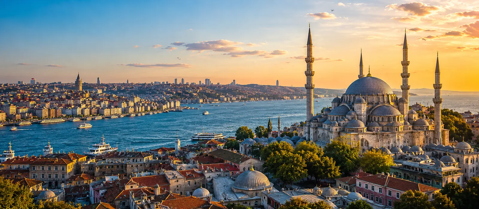
Galata Tower is about perspective rather than height because its real value comes from showing how Istanbul fits together. The observation level reveals the Golden Horn, Bosphorus, historic peninsula, Beyoğlu slopes, bridges, ferry routes, domes, roofs, apartment districts, and distant shores within one continuous geography.
The tower is high enough to separate the observer from street-level confusion, but not so detached that the city becomes an abstract pattern. Ferries remain visible as moving routes, hills still explain effort, and individual landmarks can be connected to the neighborhoods around them. Galata Tower does not merely lift the visitor above Istanbul; it teaches the visitor where Istanbul is in relation to itself.
Why Is the Tower's Position More Important Than Its Height?
Galata Tower is not extraordinarily tall beside contemporary skyscrapers. Its power comes from the combination of a substantial stone tower, an already elevated hill, and a location near the meeting point of several major urban landscapes. The view gains range before the visitor reaches the observation level.
The tower stands north of the Golden Horn, facing the historic peninsula while remaining close to the Bosphorus. This creates separation without isolation. Sultanahmet and the great mosque silhouettes can be seen across water; Karaköy descends below; Beyoğlu rises and spreads behind; bridges connect areas that the inlets visibly divide.
This is relational elevation. Greater height alone could produce a wider horizon, yet it might also flatten the distinctions that make the city readable. Galata Tower occupies a useful middle distance: above the streets, inside the metropolis, and close enough for movement to remain meaningful.
Smart Tip
Do not begin by searching for individual monuments. First locate the Golden Horn, Bosphorus, Sea of Marmara, historic peninsula, and the hill beneath Beyoğlu. Once those anchors are clear, identify bridges, ferry routes, domes, and neighborhoods. Check current official admission and opening information before visiting, especially when weather or seasonal evening programs may affect access.
How Does the View Turn Landmarks Into a Map?
At street level, Istanbul's famous structures are often experienced one at a time. A visitor reaches a mosque after several turns, crosses a square, descends toward a pier, enters a tram, and later emerges near another landmark. The transitions are physically real but mentally difficult to preserve.
From Galata Tower, those fragments become simultaneous. The historic peninsula is no longer a list containing Hagia Sophia, the Blue Mosque, Topkapı Palace, and Süleymaniye Mosque. Their positions reveal ridgelines, waterfront edges, historical concentration, and distance. The Golden Horn explains why Galata feels near the old city while remaining distinct from it.
| Direction of attention | What may draw the eye first | Perspective gained |
|---|---|---|
| Toward the historic peninsula | Domes, minarets, Topkapı, and the waterfront | Monuments occupy ridges and belong to a wider urban silhouette |
| Across the Golden Horn | Bridges, ferries, and Eminönü | The inlet separates districts while concentrating movement between them |
| Toward the Bosphorus | Water traffic and the Asian shore | The strait operates as route, boundary, and visual corridor |
| Down toward Karaköy | Roofs, slopes, streets, and waterfront development | The short map distance conceals a strong vertical transition |
| Back across Beyoğlu | Dense roofs and modern urban fabric | The tower is embedded in a living district rather than isolated as an ancient object |
The result is not perfect cartographic accuracy. Buildings overlap, haze removes detail, and the curvature of streets remains hidden. The view provides a framework rather than a complete map. Its strongest lesson is relational: water, slope, monument, transport, and neighborhood stop existing as separate categories.
Why Does Distance Change the Importance of Buildings?
Street-level attention follows size, decoration, crowds, signs, traffic, and immediate obstacles. From above, those hierarchies change. A monumental façade may become one element in a roofscape. A small ferry moving across open water can become more visually informative than a large stationary building. An ordinary hill can explain the city more clearly than a famous dome.
Distance also reveals repetition. Minarets that seem singular beside individual mosques become part of a dispersed skyline. Apartment blocks form large zones rather than isolated buildings. Green spaces interrupt density. Bridges appear not as destinations but as connections stretched over geographical problems.
This temporary flattening of prestige is useful. The visitor still recognizes major monuments, but the city around them can no longer be treated as empty background. From the tower, anonymous roofs regain the space that landmark photography usually removes from them.
How Did Seeing Far Become a Practical Function?
The present tower was built by the Genoese in the fourteenth century as part of fortified Galata. Its later uses changed under Ottoman rule, and its commanding view became especially important for observing fires. In a city where dense areas contained extensive wooden construction, smoke seen early could be an operational signal rather than a scenic detail.
That history changes the meaning of the panorama. Visitors now search for monuments, sunset color, and photographic compositions. Earlier observers could read the same broad visibility through risk: where smoke appeared, how far it had spread, which district might be threatened, and how a warning should be communicated.
A viewpoint is therefore never neutral. The same height can serve defense, surveillance, hazard detection, orientation, entertainment, tourism, or memory. Galata Tower's changing functions show that perspective gains meaning from the question being asked of the view.
The famous story of Hezarfen Ahmed Çelebi flying from the tower toward Üsküdar adds another imaginative use of elevation. It should be treated as a celebrated account associated with Evliya Çelebi rather than an event whose every detail can be independently verified. The legend survives because the tower makes the impossible route visible enough to imagine.
Does the Interior Matter if the View Is the Main Attraction?
Yes. Moving directly toward the observation level can reduce the building to an elevator supporting a balcony. The museum route and stone structure remind visitors that the viewpoint has its own biography.
The cylindrical walls, changing interior levels, exhibitions, and evidence of restoration place the panorama inside a structure that has survived damage, fire, alteration, and reuse. The present tower is associated strongly with its Genoese construction, but its appearance and functions also carry later Ottoman and modern interventions. It is not a frozen object from one year.
The interior also creates a useful reversal. Outside, the tower dominates nearby streets and becomes the object everyone photographs. Inside, the tower temporarily disappears around the visitor while the city becomes the object. Understanding both roles prevents the experience from becoming one-directional.
Why Does the Golden Horn Matter So Much to the View?
The Golden Horn gives the tower's panorama structure. Without the inlet, the historic peninsula and Galata might appear as adjacent roofscapes. Water creates a visible interval between them, clarifying why proximity did not erase their different historical identities.
Bridges then become easier to interpret. They are not merely lines carrying traffic; they join commercial districts, transport nodes, walking routes, and historical zones across an urban waterway. Ferries and smaller vessels add diagonal movement that bridges alone cannot provide.
The inlet also guides the eye inland. Its shores display layers of port activity, commerce, religious architecture, road infrastructure, restoration, and redevelopment. The tower's view is strongest when the Golden Horn is followed as a spatial system rather than used only as reflective foreground beneath the old-city skyline.
Can a 360-Degree View Still Produce a Narrow Understanding?
Yes. A visitor can circle the observation level and still look only toward the most recognizable skyline. The phrase “360-degree view” describes physical access to direction, not equal attention to every direction.
The historic peninsula naturally attracts cameras, especially when light outlines its domes and minarets. Yet Beyoğlu behind the tower, the dense streets below, industrial and commercial traces around the Golden Horn, the Asian shore, and ordinary residential areas explain why the famous silhouette exists within a metropolis rather than apart from it.
Crowd behavior can narrow attention further. Visitors cluster at familiar compositions, wait for a photograph, and move quickly through less obvious sections. A more complete circuit gives each direction a specific question:
- Where does the land rise? This reveals why walking routes feel different from map distance.
- Where does water concentrate movement? This identifies piers, bridges, and crossing patterns.
- Where does the skyline lose monumentality? This shows the transition into ordinary urban fabric.
- Which places face one another? This makes cross-water relationships visible.
- What cannot be seen? This preserves awareness that every panorama has blind spots.
When Does Light Improve the View—and When Does It Hide It?
Clear daylight favors orientation. Shorelines, hills, roofs, bridges, and distant districts remain separable. The view may appear less dramatic than sunset, but it provides stronger evidence for understanding the city's physical structure.
Late light can make the historic peninsula intensely memorable. Silhouettes sharpen, water changes color, and artificial lights begin to reorganize the skyline. The trade-off is reduced detail. A beautiful outline may conceal the street texture, slopes, and ordinary buildings that make perspective informative.
Haze compresses distance and can partially erase the Asian shore or outer districts. Rain changes reflections and visibility. Wind affects comfort on the exposed observation route. Night emphasizes illuminated symbols while allowing darker neighborhoods and water boundaries to recede.
No single condition provides the complete Galata Tower view. Daylight explains; sunset dramatizes; darkness edits. Choosing a time means choosing which version of perspective receives priority.
How Do Crowds Change the Meaning of the Observation Level?
The viewing route is physically limited. When many visitors stop for extended photographs, the panorama becomes a sequence of negotiated positions. Attention shifts from the city to available railing space, approaching groups, and the pressure to move.
This does not make the visit worthless. It means perspective must be gathered in shorter observations. One deliberate look can establish the Golden Horn. Another can follow the Bosphorus. A third can examine the roofs directly below. The visitor does not need to hold every ideal position at once.
Courtesy also improves interpretation. Moving after a reasonable pause allows others to see, while returning to a less crowded side may reveal something missed earlier. Phones and cameras should remain secure, and all posted safety or circulation instructions should be followed. The observation level is a shared route, not a private terrace.
Why Can the Descent Be More Important Than the Panorama?
The view becomes useful when it changes the streets afterward. A visitor who noticed Karaköy's slope may better understand the descent. Someone who saw the Golden Horn as a boundary may read Galata Bridge differently. The relationship between Galata, Eminönü, Sultanahmet, and the Bosphorus becomes easier to retain during later journeys.
Descending also restores details that elevation removed. Shopfronts, stone surfaces, stairways, side streets, voices, deliveries, cables, trees, and crowd movement return. The panorama and the street correct one another: the tower provides structure, while walking supplies texture.
| Viewing habit | Immediate result | What remains after descent |
|---|---|---|
| Collecting landmark photographs | A recognizable visual record | Limited improvement in orientation |
| Following shorelines first | A clear framework for the panorama | Better understanding of crossings and district boundaries |
| Comparing hills and roofs | Visible differences in elevation and density | More realistic expectations about walking effort |
| Watching moving ferries | Transport routes become visible lines | Piers feel connected rather than isolated |
| Reading the museum and the view together | The tower becomes both object and observer | Its changing historical functions remain part of the memory |
What Makes Galata Tower More Useful Than a Taller Viewpoint?
A much taller building can show greater distance and more of metropolitan Istanbul. It may reveal urban expansion, highway corridors, modern business districts, and the scale of development beyond the historic center. Galata Tower offers a different advantage.
Its position belongs to the history being observed. The tower stands inside the relationship among Galata, the Golden Horn, the Bosphorus, and the historic peninsula. The city has grown around its silhouette, used its visibility, repaired it, changed its function, and continued to orient itself through its presence.
That embeddedness prevents the panorama from becoming generic. Visitors do not simply see Istanbul from above; they see it from a structure that has long participated in watching, warning, defending, imagining, and representing the city.
Galata Tower matters not because it defeats Istanbul in height, but because it stands at the point where Istanbul becomes legible in several directions at once.
Did You Know?
The present Galata Tower was built by the Genoese in 1348 and was known as the Tower of Christ. Its later roles included observing fires, making the panorama a working field of risk detection long before it became one of Istanbul's most famous visitor views.
Jean Mustafa Kowalski Nakamurason Hernández Obromoviç
Always Local
“I climbed up to see how small Istanbul looked. Istanbul refused. The Golden Horn became a sentence, the ferries supplied punctuation, the hills corrected my walking plans, and six neighborhoods I had filed separately began arguing across the water. I came down shorter than the tower but geographically improved.”
Who is this guy?